The weather forecast for northwestern Oklahoma and southern Kansas shows some leftover showers early Tuesday morning, with no severe weather expected as the system moves out. The main upper-level trough will linger in the area on Tuesday, bringing clouds and a chance of spotty showers along the OK-KS state line. Gusty north winds will usher in cooler weather, with morning lows in the 40s and afternoon highs only in the lower to mid-50s.
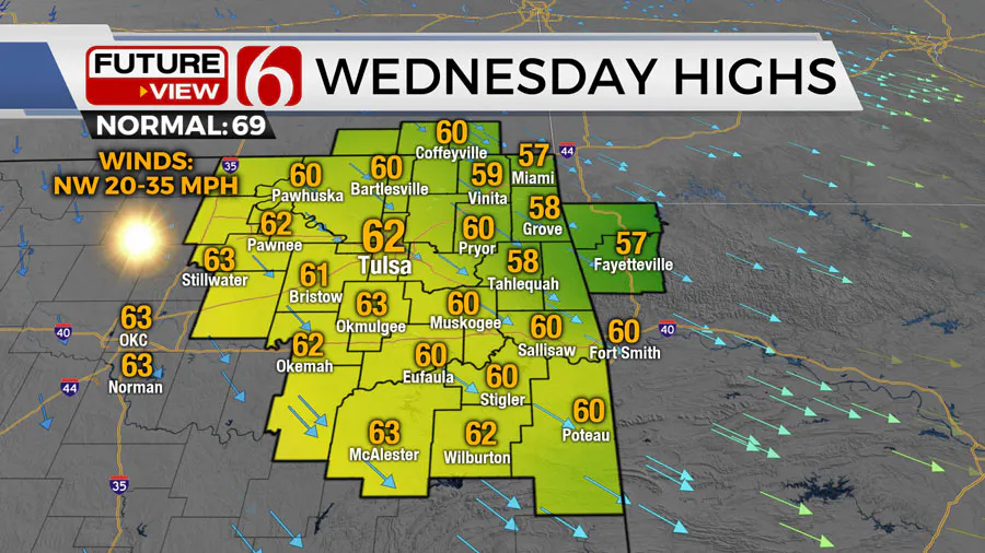
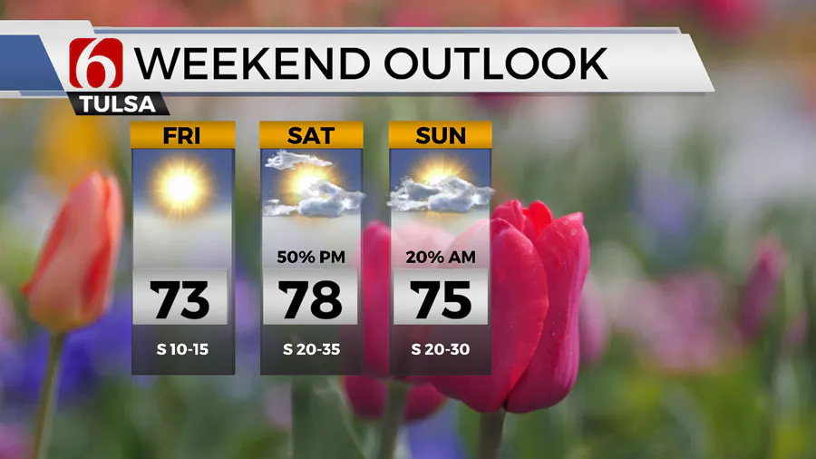
Wednesday and Thursday mornings will still start cool in the 30s, but highs will reach the 60s. By Friday, south winds will return, pushing afternoon highs into the lower to mid-70s. The weekend will bring more spring-like temperatures, with morning lows in the 50s and afternoon highs in the upper 70s, accompanied by gusty south winds.
You may also like to watch : Who Is Kamala Harris? Biography - Parents - Husband - Sister - Career - Indian - Jamaican Heritage
Another storm system is expected to approach the state over the weekend, increasing thunderstorm chances with additional storms possible early next week. The upper air flow is likely to produce a strong trough near the Aleutian Island chains on Tuesday, which will move towards the southwestern United States by Friday and the four corners area by Saturday. This will bring the potential for strong to severe storms across the western half of the state on Saturday evening, with some storms moving into the area late Saturday night and exiting early Sunday morning.
By Sunday, the main upper-level system will weaken as it moves into the central plains, but another strong trough is expected to develop across southern California and move eastward towards the southern plains by Tuesday. Storm activity is likely to develop late Saturday night across the western half of the state, moving eastward and impacting the area late Saturday evening into pre-dawn Sunday morning.
Improving conditions are expected on Sunday afternoon and evening as the system moves out, bringing sunshine and dry low-level flow. Looking ahead to next week, a new upper-level trough will develop to the west of Oklahoma, potentially bringing some clouds to the southern plains on Monday before storm chances return late Monday afternoon or early Tuesday morning. The main upper-level trough for this period could bring additional storms on Tuesday and Wednesday, with the possibility of severe weather based on pattern recognition.
Eclipse Monday will fall between these two weather systems, with the forecast for northeastern Oklahoma currently calling for partly cloudy skies and a high near 78, with south winds at 10 to 20 mph. Changes to the forecast are possible as the day approaches.
You may also like to watch: Is US-NATO Prepared For A Potential Nuclear War With Russia - China And North Korea?
To stay updated on the latest weather information, you can listen to the Alan Crone morning weather podcast on Spotify or Apple Podcasts. You can also follow the News On 6 Meteorologists on Facebook for real-time updates and forecasts.
In conclusion, the weather in northwestern Oklahoma and southern Kansas will see a mix of showers, cooler temperatures, and the potential for severe storms over the weekend. Stay informed and prepared for changing weather conditions by following reliable sources and staying up-to-date on the latest forecast information..
Some leftover showers continue early Tuesday morning across northwestern OK and southern Kansas. No additional severe weather threats are expected with this departing system.
The main upper-level trough associated with our current storm will remain near the area for most of Tuesday. This will keep clouds across the area with a low possibility of a few spotty showers along the OK-KS state line region.
Gusty north winds from 15 to 30 mph will drive cooler weather into the area with morning lows in the 40s and afternoon highs only in the lower to mid-50s.

Temps both Wednesday and Thursday morning still start in the 30s with highs in the 60s. We’ll see a return of south winds Friday with afternoon highs reaching the lower to mid-70s.
Temps will be more spring-like this weekend with morning lows in the 50s and afternoon highs in the upper 70s with gusty south winds.
Another storm system nears the state with increasing thunderstorm chances this weekend with additional chances following into early next week.
Are there storm chances this weekend in Oklahoma?
The upper air flow is likely to produce another broad and strong trough Tuesday near the Aleutian Island chains.
This strong upper-level feature will near the southwestern United States Friday and near the four corners area of the intermountain region Saturday bringing another round of strong to severe storms across the western half of the state Saturday evening.
A few of these storms will move into our area late Saturday night and exit early Sunday morning.

By Sunday the main upper-level system will more than likely begin weakening as it ejects into the central plains, but another strong trough is also likely to develop Sunday and Monday across southern California and move slowly eastward near the southern plains Tuesday.
A swath of storm activity is likely to develop late Saturday night across the western half of the state as the above-mentioned trough nears the area.
These storms will quickly move eastward late Saturday evening and impact our general area late Saturday evening into pre-dawn Sunday morning.
We should see some improving conditions Sunday afternoon and evening behind this departing system with sunshine and dry low-level flow.
What will the weather be like next week in Oklahoma?
By Monday, the next upper-level trough developing to our west will have a chance of producing some clouds across part of the southern plains before storm chances return either late Monday afternoon or early Tuesday morning.
The main upper-level trough for this period will bring additional storms Tuesday into Wednesday of next week, including severe weather threats based on pattern recognition.
Eclipse Monday will be in-between these two systems.
Our forecast for northeastern OK for Eclipse Monday is currently partly cloudy with a high near 78 with south winds at 10 to 20 mph. Additional changes are possible for Monday.
The Alan Crone morning weather podcast link from Spotify:
https://open.spotify.com/episode/5j0ovActG8BZCOTqZQzrfU
The Alan Crone morning weather podcast link from Apple:
https://podcasts.apple.com/us/podcast/weather-out-the-door/id1499556141?i=1000646589555
Follow the News On 6 Meteorologists on Facebook!
Source
News On 6 said Blustery, Cool Weather Following Severe Storms Overnight In Green Country
RELATED STORY.


